News Summary
Georgetown residents can expect severe thunderstorms on Friday evening as a low-pressure system moves in. Small hail, gusty winds, and lightning will accompany the storms, followed by a drop in temperatures for the weekend. Saturday will see highs in the mid to low 60s, and Sunday promises a warming trend with temperature highs in the upper 60s to low 70s. However, pollen counts are set to rise, impacting allergy sufferers. Stay safe during the storm and heed tornado alerts if in the affected areas.
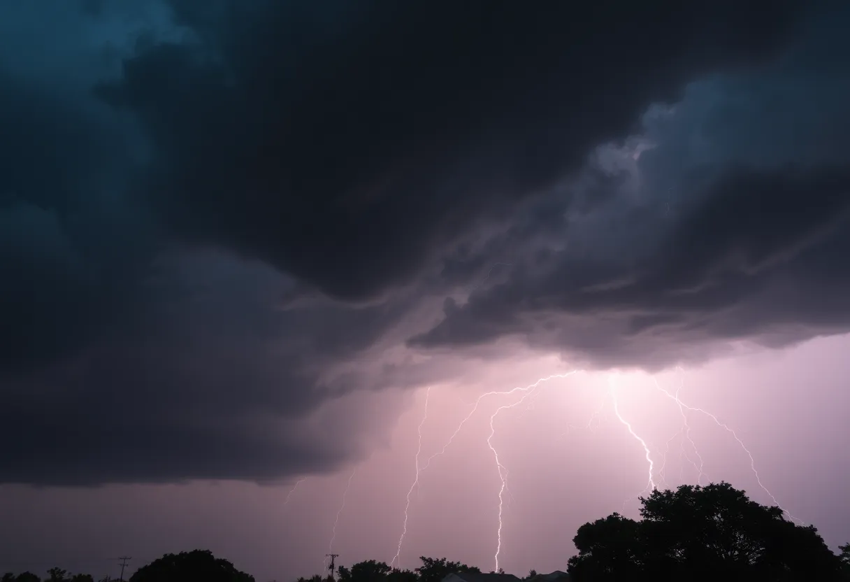
Severe Thunderstorms Predicted in Georgetown Area with Cooling Temperatures This Weekend
Hey there, Georgetown! It looks like we’re in for an eventful weekend courtesy of Mother Nature. So, hold onto your hats (and maybe your umbrellas) because Friday evening is set to bring quite a spectacle!
What to Expect This Evening
As we head into the evening, an area of low pressure is making its way through, which means showers and thunderstorms will be rolling into the Georgetown region. The forecast is predicting that these storms could bring along some small hail, gusty winds, and plenty of lightning. Sounds intense, right? The storm activity is expected to calm down later in the night as this low-pressure system moves offshore, making room for a cold front to sweep in.
Chilly Nights Ahead
If you’re planning on staying out late Friday night, be ready for a sudden drop in temperatures. Overnight, we can expect things to get a touch chilly as skies clear up for Saturday morning. Daylight on Saturday will boast cooler than normal temperatures for this time of year, with highs lingering in the mid to low 60s. Still warm yet crisp enough for a light jacket!
For our friends further south in the Pee Dee and Grand Strand, you might be enjoying slightly warmer weather, with temps hitting the upper 60s on Saturday. Not too shabby!
Weekend Outlook
As Saturday night rolls in, the forecast calls for mostly clear skies, but keep an eye on those temperatures—especially in the Pee Dee and Border Belt regions. A few chilly spots could drop to the upper 30s before dawn, but you can rest easy, frost is not expected. Phew!
Now here’s a little good news; Sunday looks like it’ll bring a warming trend as high pressure moves back into the area. Expect to bask in some sunshine with highs climbing into the upper 60s to low 70s—perfect for a lovely weekend outing!
Pollen Alerts and More
However, not all is sun and fun this weekend. If you suffer from allergies, make sure to take note; pollen counts are set to soar this weekend due to oak, willow, and birch pollen. Gulp! Dreaded allergies could be in full swing!
But wait, there’s more! By Tuesday, pollen counts are expected to dip into the medium category because another weather maker will waltz through. That upcoming weak cold front might even stir up additional showers or thunderstorms across the Grand Strand, Pee Dee, and Border Belt.
Short-lived Warm Spell
Before we get to that though, Monday and Tuesday afternoons promise some warmth as temperatures rise to the low 80s to upper 70s. But just as quickly as the warmth arrives, we may usher in another cooling stretch midweek.
Stay Safe Out There
Heads up, folks! The National Weather Service has issued a tornado alert for strong thunderstorms in areas including Inland Georgetown and Coastal Georgetown until 8:30 p.m. Expect wind gusts up to 50 mph, so it’s best to seek shelter indoors if you’re outdoors during the storms. The alert covers areas like Georgetown Memorial Hospital, North Santee, Sampit, Georgetown, and DeBordieu Colony.
For everyone driving home, remember to exercise caution. Hydroplaning is a risk when roads are slick with water buildup, and nobody wants to deal with that hassle.
So let’s gear up and face the weekend, Georgetown! Be safe, stay informed, and maybe check that umbrella one more time before you head out!
Deeper Dive: News & Info About This Topic
HERE Resources
Severe Thunderstorm Alerts Hit South Carolina: What You Need to Know
Severe Thunderstorm Watch Issued for Tennessee Valley and Indiana
Severe Thunderstorm Watch Issued for Myrtle Beach
Severe Thunderstorm Warnings Issued for Myrtle Beach
Publix to Open New Grocery Store in Florence, SC
Myrtle Beach Faces Increased Fire Danger Alert
Myrtle Beach Faces Red Flag Fire Warning Amid Dry and Breezy Conditions
Red Flag Fire Alert Issued for South Carolina and North Carolina
Weather Alerts Issued for Myrtle Beach and Surrounding Areas
South Carolina Residents Get More Time for Disaster Loans
Additional Resources
- Herald Online
- Weather.com: Georgetown, TX 10-Day Forecast
- Community Impact: Georgetown Freeze Warning
- Live 5 News: Winter Weather Advisories
- Google Search: Georgetown Weather